
The use of advanced technologies has become a key factor for the competitiveness of organizations. In Volartech we have it very clear and that is why we are experts in the implementation of techniques and cutting-edge digital tools, oriented to the construction and real estate sector. So, through drones, HD cameras, sensors, and specialized software, we are able to make different types of videos and photographs, as well as create their virtual representations from as-built drawings; 3D models that are now known as Digital Twins.
Previously, we shared with you what they are and why implement them in construction projects. However, here we present a successful case to give you a better understanding of how they are created.
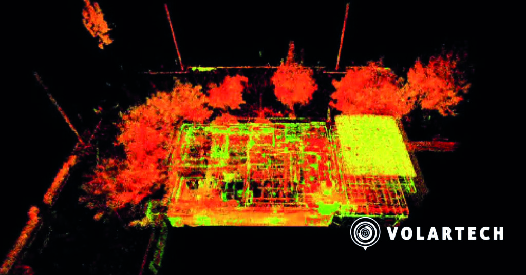
For this, we go back to 2023, when a renowned private non-profit institution in Bogotá, hired us to build an exact virtual replica of its 700 m² facilities.
We began the process by capturing the data of the building through several drone flights and scans with a terrestrial laser sensor, using the method of differential static satellite positioning with multiband GNSS receivers; an advanced technique used to determine with great precision the geographic coordinates of a specific point.
This data capture was performed with different software that allowed our operators to give a real-time pre-registration of the point cloud (LiDAR), in addition to adding photos, annotations, and comments when necessary.
Subsequently, to ensure the georeferencing of the products obtained, we used a topographic technique called polygonal, to adjust a series of reference points, and obtain an accurate measurement of the location and shape of the structure.
In this way, when we verified that the data and the locations of each element that made up the building were in place, we finished the process, since we achieved our goal: to capture 100% of the physical reality of the property.
These are the 3 most important achievements we highlight from the project
Range: one of the most notable advantages of the terrestrial laser scanner technology was its ability to capture difficult-to-access spaces without any inconvenience, since it can take data from 50 meters around. On the other hand, the drone allowed us to access 100% of the perimeter of the structure, without putting the operators at risk.
Data acquisition and processing: by implementing the laser scanner to capture data, we obtained a 467% yield with respect to the traditional methodology, which saved us time and resources, providing us with an important space to meet with the management team and make decisions.
Also, during processing, we had a 400% yield, higher than what we would have achieved with the conventional method.
Level of detail and versatility in the results: by means of our tools and technologies, it is possible to obtain 70 million point density per 1,000 m², which allows us to record each piece of data with greater precision.
On the other hand, by having the virtual representation of the facilities, they will be able to make measurements, adjustments and remodeling in the short and long term.
This success story is a clear testimony of how advanced technologies and Digital Twins are revolutionizing the field of construction and real estate, giving organizations an unparalleled competitive advantage. At Volartech, we remain committed to innovation and excellence, and we are ready to face new challenges and remain at the forefront of the industry to deliver outstanding solutions to our clients. Get to know us here.